Tunnel island

Kalsoy

A long, narrow island of tunnels, sea cliffs and compact settlements where a single road follows the limited space between mountain and water.

Sea cliffsTunnelsSmall villages

Location
Northern Isles, Faroe Islands
Best window
May-Sep
Suggested stay
2-4 days
Go for
North Atlantic edge
The reason to go

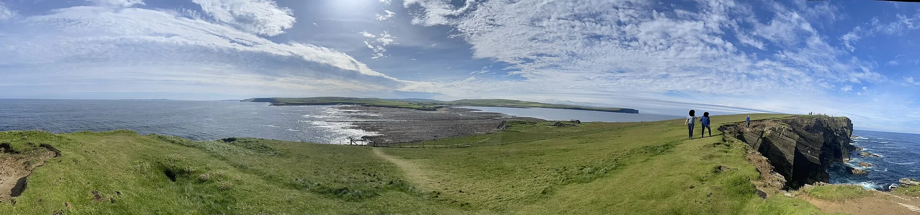
Kallur headland

The northern headland combines a small lighthouse, exposed ridges and wide views across several Faroese islands.

Plan the least frequent boat, ferry or exposed coastal section first. Use early or late light and keep a weather alternative during May-Sep.

Look a little closer

Worth discovering

The details that make Kalsoy different.

Destination view
01

Kallur headland

The northern headland combines a small lighthouse, exposed ridges and wide views across several Faroese islands.

Photo journal
02

Mountain tunnels

The road passes through a succession of tunnels, making the island's topography part of every journey.

Photo journal
03

Mikladalur

A compact village, local folklore and the steep descent to the harbour show the human scale of the island.

Photo journal

A closer look at Kalsoy

12 photographs
Origins and change

A deeper history of Kalsoy

A long, narrow island of tunnels, sea cliffs and compact settlements where a single road follows the limited space between mountain and water. The deeper story links its visible features with the people and changes behind them.

Kalsoy is shaped like a mountain ridge set directly into the North Atlantic. Steep slopes fall toward narrow coastal shelves, leaving little room for roads or settlement. A sequence of tunnels links the island's small villages, and the road eventually ends near Trollanes, where paths continue toward the northern cliffs and Kallur lighthouse.

Many visits to Kalsoy begin with the experience described as “Kallur headland”. The more revealing question is why it exists here, how people used the surrounding ground and what remains visible from earlier phases. The northern headland combines a small lighthouse, exposed ridges and wide views across several Faroese islands.

Continue to practical planning
Kalsoy Mikladalur.1See the complete photo journal
Natural history

The forces behind the first impression

Understanding Kalsoy starts below the visible surface. The island's form is simple but severe: green slopes, dark rock, deep fjords and an exposed western coast. Weather moves quickly across the ridge, alternately revealing and hiding neighbouring islands. Because the land is so narrow, the sea is almost always present, even when the road passes through the mountain rather than along the shore.

On an island, coast, altitude and exposure work together. At Kalsoy, the feature described as “Kallur headland” shows how a short distance can separate sheltered ground from a very different ocean-facing environment. The northern headland combines a small lighthouse, exposed ridges and wide views across several Faroese islands.

Cultural landscape

How people learned to live here

Kalsoy has been shaped as much by livelihoods and movement as by natural processes. Mikladalur, Husar, Sydradalur and Trollanes each occupy small areas of workable ground. Houses cluster tightly, boats remain important, and the scale of settlement makes daily life visibly dependent on ferry schedules, roads and weather. Folklore, local art and the story of the seal woman add a cultural layer to an island often presented only through dramatic photographs.

At Kalsoy, the feature described as “Mountain tunnels” offers a second line of evidence. The road passes through a succession of tunnels, making the island's topography part of every journey. Within Kalsoy, it shows how local knowledge and practical use became embedded in the landscape.

Turning point

A landscape reorganised

The decisive modern change at Kalsoy was access. At Kalsoy, transport and visitor infrastructure made the landscape easier to reach while concentrating pressure at the few points where roads, boats or trails enter it. Kalsoy should therefore be read as an evolving cultural landscape rather than a timeless scene.

Details to read

What to read in the landscape

At Kalsoy, the feature “Kallur headland” provides a precise clue to how the landscape works. The northern headland combines a small lighthouse, exposed ridges and wide views across several Faroese islands. At Kalsoy, it gives a concrete reference point for reading change rather than merely collecting viewpoints.

At Kalsoy, the feature “Mountain tunnels” is one of the most useful pieces of visible evidence. The road passes through a succession of tunnels, making the island's topography part of every journey. At Kalsoy, the detail links local scale with the wider regional pattern.

At Kalsoy, the feature “Mikladalur” is best understood as part of the surrounding system rather than an isolated stop. A compact village, local folklore and the steep descent to the harbour show the human scale of the island. Within Kalsoy, the feature explains why this destination differs from nearby landscapes.

Present day

A living landscape, not a frozen scene

At Kalsoy, light, water and temperature reveal different structures at different times of year. Late spring and summer provide longer daylight and generally more reliable connections, but wind and low cloud remain normal. Autumn brings stronger contrasts and fewer visitors. In winter, short days and changing sea conditions place greater emphasis on the island's working rhythm rather than its viewpoints.

For Kalsoy, the main seasonal constraint is: the strongest planning window is May-Sep. For Kalsoy, outside it, check weather, daylight, road or ferry schedules and seasonal closures before committing to a fixed route.

For Kalsoy, one practical detail matters: ferries, tunnels and weather can change the order of the day. For Kalsoy, build the route around the least frequent connection, not the closest viewpoint.

Placed within its wider geography, Kalsoy is not an isolated exception. Kalsoy belongs to the northern Faroese group with Kunoy, Bordoy, Vidoy and Fugloy. For Kalsoy, ferries, tunnels and causeways connect parts of this landscape, yet each island retains a distinct relationship between road, village and mountain. Seeing Kalsoy in this context explains why its apparent isolation is part of a larger inhabited archipelago.
Travel notes

Plan your visit

Time needed
2-4 days
Getting around
Car or local transport, plus ferries or boats and short walks
Effort
Moderate
Plan first
Main transport and accommodation
Time of day
Start early for clearer conditions and more time
Best window
May-Sep
Traveller stories

Stories from people who have been here.

First-hand moments, practical notes and overlooked details from Kalsoy.

Loading traveller stories…

Browse all traveller stories ↗

Keep exploring

Where next?

All place stories