Ruined mountain of gold

Las Medulas

Red earth pinnacles, chestnut woods and tunnels left by Roman gold mining create a cultural landscape unlike the surrounding hills of northwestern Spain.

Roman miningRed cliffsChestnut woods

Location
Leon, Spain
Best window
Mar-Nov
Suggested stay
2-4 days
Go for
Archaeology in the landscape
The reason to go

Orellan viewpoint

A high perspective reveals the scale of the excavated basin and the contrast between red pinnacles and surrounding forest.

Check opening days or local access first, then connect the main site to the surrounding streets, paths or landscape instead of treating it as an isolated stop.

Look a little closer

Worth discovering

The details that make Las Medulas different.

Destination view
01

Orellan viewpoint

A high perspective reveals the scale of the excavated basin and the contrast between red pinnacles and surrounding forest.

Destination view
02

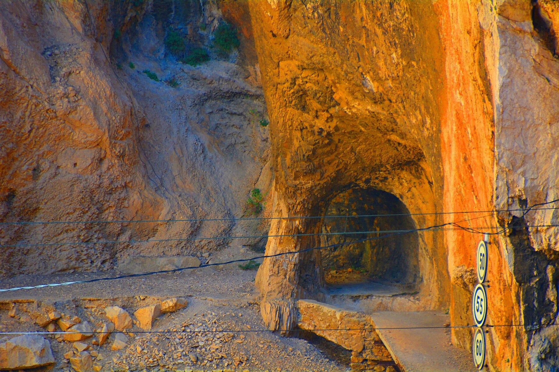
Mining tunnels

Surviving galleries show how water and gravity were used to destabilize the mountain from within.

Destination view
03

Chestnut landscape

Old trees and small plots demonstrate how later rural life adapted to terrain transformed by ancient extraction.

Photo journal

A closer look at Las Medulas

13 photographs
Beyond the surface

How Las Medulas became the place it is

Red earth pinnacles, chestnut woods and tunnels left by Roman gold mining create a cultural landscape unlike the surrounding hills of northwestern Spain. The view is only the surface of a longer story of formation, use and change.

Las Medulas is not a natural badland in the usual sense. Its broken red ridges are the result of a vast Roman mining system that redirected water through channels and tunnels to collapse sections of the mountain. Centuries of vegetation have softened the engineered terrain without hiding its scale.

Visitors often encounter Las Medulas through the idea of “Orellan viewpoint”, but the destination is more than that single scene. Its landscape carries evidence of work, movement, adaptation and environmental change. A high perspective reveals the scale of the excavated basin and the contrast between red pinnacles and surrounding forest.

Continue to practical planning
Las Médulas Roman Goldmines 03See the complete photo journal
Natural history

How the landscape was assembled

Understanding Las Medulas starts below the visible surface. Iron-rich earth forms sharp towers, gullies and exposed walls between mature chestnut groves. From higher paths, the excavated zone appears as a basin of red fragments set against greener mountains. The contrast between woodland and disturbed geology makes the mining footprint readable even without machinery or standing buildings.

Altitude turns distance into effort and creates abrupt ecological boundaries. At Las Medulas, “Orellan viewpoint” provides a useful reference point for understanding that vertical structure. A high perspective reveals the scale of the excavated basin and the contrast between red pinnacles and surrounding forest.

Cultural landscape

People, work and memory

Las Medulas has been shaped as much by livelihoods and movement as by natural processes. Roman extraction depended on water control, surveying, labor and a regional network extending far beyond the visible pit. Later communities cultivated chestnuts and used paths that crossed the former mine. The present landscape therefore joins imperial engineering with long rural continuity rather than freezing one historical period.

A close look at “Mining tunnels” makes the cultural layer of Las Medulas more concrete. Surviving galleries show how water and gravity were used to destabilize the mountain from within. At Las Medulas, the surviving form links present-day identity with earlier work and settlement.

Change

How access and attention changed the place

Formal protection changed how Las Medulas was described and managed. At Las Medulas, new boundaries, visitor rules and conservation priorities created a public identity that still has to coexist with settlements, customary use and economic pressures. At Las Medulas, the consequences are clearest where traditional use, protection and tourism occupy the same ground.

On the ground

Where the story becomes visible

Start with the feature “Orellan viewpoint”, because it condenses a much larger part of the story of Las Medulas. A high perspective reveals the scale of the excavated basin and the contrast between red pinnacles and surrounding forest. At Las Medulas, the detail links local scale with the wider regional pattern.

At Las Medulas, the feature “Mining tunnels” provides a precise clue to how the landscape works. Surviving galleries show how water and gravity were used to destabilize the mountain from within. At Las Medulas, it gives a concrete reference point for reading change rather than merely collecting viewpoints.

At Las Medulas, the feature “Chestnut landscape” is one of the most useful pieces of visible evidence. Old trees and small plots demonstrate how later rural life adapted to terrain transformed by ancient extraction. For Las Medulas, that relationship is more informative than treating the feature only as a photograph or checklist item.

Continuity

A living landscape, not a frozen scene

A single visit to Las Medulas captures only one phase of its annual cycle. Spring brings green understory and clear walking conditions, while autumn adds strong color to the chestnut woods. Summer can be hot and exposed on open ridges. Winter is quieter, but wet weather can make clay surfaces slippery and reduce access to some paths.

For Las Medulas, the main seasonal constraint is: the strongest planning window is Mar-Nov. For Las Medulas, outside it, check weather, daylight, road or ferry schedules and seasonal closures before committing to a fixed route.

For Las Medulas, one practical detail matters: cloud, wind and trail conditions can change quickly. For Las Medulas, put the highest or most exposed stop first and keep a lower-level alternative.

Placed within its wider geography, Las Medulas is not an isolated exception. For Las Medulas, the wider context shows that, the wider El Bierzo region includes villages, vineyards, mountain roads and pilgrimage routes. Las Medulas gains depth when seen as one part of that inhabited basin, where archaeology, agriculture and contemporary conservation continue to overlap.

Travel notes

Plan your visit

Time needed
2-4 days
Getting around
Car to access points, then walking or hiking
Effort
Moderate
Plan first
Opening days and any limited-entry sites
Time of day
Start early for clearer conditions and more time
Best window
Mar-Nov
Traveller stories

Stories from people who have been here.

First-hand moments, practical notes and overlooked details from Las Medulas.

Loading traveller stories…

Browse all traveller stories ↗

Keep exploring

Where next?

All place stories