Northern river bend

Nong Khiaw

A riverside settlement in northern Laos enclosed by limestone towers, forest and tributary valleys reached by boat, road and footpath.

Karst valleyNam Ou RiverVillage trails

Location
Nam Ou Valley, Laos
Best window
Nov-Mar
Suggested stay
2-4 days
Go for
River and karst days
The reason to go

Nam Ou bridge

The central crossing frames the river and limestone walls while linking the two halves of the settlement.

Check opening days or local access first, then connect the main site to the surrounding streets, paths or landscape instead of treating it as an isolated stop.

Look a little closer

Worth discovering

The details that make Nong Khiaw different.

Photo journal
01

Nam Ou bridge

The central crossing frames the river and limestone walls while linking the two halves of the settlement.

Destination view
02

Viewpoint ridges

Steep paths open above the town and reveal the scale of the surrounding karst valley.

Destination view
03

Upper-river villages

Boat and road journeys extend the experience toward smaller communities and quieter sections of the Nam Ou.

Photo journal

A closer look at Nong Khiaw

16 photographs
Beyond the surface

The landscape memory of Nong Khiaw

A riverside settlement in northern Laos enclosed by limestone towers, forest and tributary valleys reached by boat, road and footpath. The view is only the surface of a longer story of formation, use and change.

Nong Khiaw sits on both banks of the Nam Ou River beneath steep limestone formations in northern Laos. A bridge joins the two sides of town, while tracks and river routes continue toward smaller villages and mountain valleys. The settlement has developed as a travel base, but its geography remains legible in the close relationship between homes, water and karst walls.

The familiar invitation at Nong Khiaw is “Nam Ou bridge”, yet that image makes more sense when it is connected to the landform, the local economy and the changes that determined access. The central crossing frames the river and limestone walls while linking the two halves of the settlement.

Continue to practical planning
Nong Khiaw pano(4)See the complete photo journal
Landform

From underlying structure to visible landscape

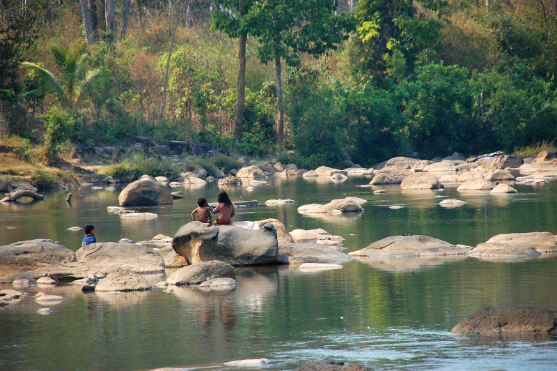
Before roads, settlements or protected-area boundaries, the terrain of Nong Khiaw set the basic terms. The Nam Ou creates a broad reflective corridor through otherwise abrupt terrain. Limestone towers rise directly behind cultivated land and forest, and morning mist often separates their upper slopes from the valley. Viewpoint trails reveal how narrow the inhabitable ground is compared with the surrounding mountain mass.

Movement is the organising idea at Nong Khiaw. “Nam Ou bridge” explains how the route negotiates an obstacle that would otherwise divide the landscape. The central crossing frames the river and limestone walls while linking the two halves of the settlement.

Lives and livelihoods

The human landscape behind the scenery

Nong Khiaw has been shaped as much by livelihoods and movement as by natural processes. Markets, guesthouses, schools and riverside homes make Nong Khiaw an active regional settlement rather than an isolated scenic outpost. Nearby villages retain agricultural and craft traditions, though road development and tourism are changing movement along the valley. Boat travel remains important for understanding the river's role.

The role of “Viewpoint ridges” is especially revealing at Nong Khiaw. Steep paths open above the town and reveal the scale of the surrounding karst valley. In the history of Nong Khiaw, it connects the wider regional context with a specific place that can still be examined today.

Turning point

A landscape reorganised

The decisive modern change at Nong Khiaw was access. At Nong Khiaw, transport and visitor infrastructure made the landscape easier to reach while concentrating pressure at the few points where roads, boats or trails enter it. At Nong Khiaw, that transition remains visible in the contrast between older working features and visitor infrastructure.

On the ground

Where the story becomes visible

At Nong Khiaw, the feature “Nam Ou bridge” provides a precise clue to how the landscape works. The central crossing frames the river and limestone walls while linking the two halves of the settlement. Its position and condition at Nong Khiaw connect physical history with the way people use the place now.

At Nong Khiaw, the significance of the feature “Viewpoint ridges” goes beyond its visual impact. Steep paths open above the town and reveal the scale of the surrounding karst valley. Its position and condition at Nong Khiaw connect physical history with the way people use the place now.

At Nong Khiaw, the significance of the feature “Upper-river villages” goes beyond its visual impact. Boat and road journeys extend the experience toward smaller communities and quieter sections of the Nam Ou. Within Nong Khiaw, it is both an attraction and a record of the processes described above.

Continuity

What continues to change

Nong Khiaw changes through the year because weather and biological cycles rearrange what can be seen and used. The cooler dry months from November to March generally provide comfortable walking and clearer viewpoints. The hot season can be hazy, while monsoon months bring lush vegetation, high water and more difficult trails. River and road conditions should be treated as part of the landscape rather than assumed to be constant.

For Nong Khiaw, the main seasonal constraint is: the strongest planning window is Nov-Mar. For Nong Khiaw, outside it, check weather, daylight, road or ferry schedules and seasonal closures before committing to a fixed route.

For Nong Khiaw, one practical detail matters: cloud, wind and trail conditions can change quickly. For Nong Khiaw, put the highest or most exposed stop first and keep a lower-level alternative.

Placed within its wider geography, Nong Khiaw is not an isolated exception. Nong Khiaw connects with Muang Ngoi, Luang Prabang and more remote northern districts. For Nong Khiaw, staying beyond a single sunset viewpoint allows the valley's villages, river traffic and surrounding paths to become the main story.
Travel notes

Plan your visit

Time needed
2-4 days
Getting around
Car to access points, then walking or hiking
Effort
Moderate
Plan first
Accommodation and seasonal transport
Time of day
Start early for clearer conditions and more time
Best window
Nov-Mar
Traveller stories

Stories from people who have been here.

First-hand moments, practical notes and overlooked details from Nong Khiaw.

Loading traveller stories…

Browse all traveller stories ↗

Keep exploring

Where next?

All place stories