Four Thousand Islands

Si Phan Don

A broad Mekong river landscape of islands, channels, rapids and farming communities unfolds near the Laos-Cambodia border.

Mekong islandsWaterfallsVillage life

Location
Mekong River, Laos
Best window
Nov-Mar
Suggested stay
2-4 days
Go for
River island days
The reason to go

Khone Phapheng falls

The Mekong compresses into a powerful broken front, revealing why navigation historically stopped at this section.

Plan the least frequent boat, ferry or exposed coastal section first. Use early or late light and keep a weather alternative during Nov-Mar.

Look a little closer

Worth discovering

The details that make Si Phan Don different.

Photo journal
01

Khone Phapheng falls

The Mekong compresses into a powerful broken front, revealing why navigation historically stopped at this section.

Photo journal
02

Don Khon and Don Det

Connected islands combine village roads, old railway traces and easy access to several river channels.

Photo journal
03

Quiet outer islands

Less-visited communities show the agricultural and fishing landscape beyond the main guesthouse areas.

Photo journal

A closer look at Si Phan Don

10 photographs
Beyond the surface

Si Phan Don beyond the first view

A broad Mekong river landscape of islands, channels, rapids and farming communities unfolds near the Laos-Cambodia border. Its character becomes clearer when geology, settlement and modern protection are considered together.

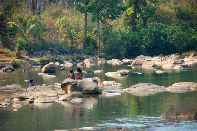
Si Phan Don occupies a wide section of the Mekong where the river separates into many channels around islands and seasonal sandbanks. The landscape feels horizontal and water-led, with settlement, agriculture and transport organised around the changing river rather than a continuous road network.

The strongest visual shorthand for Si Phan Don is the experience described as “Khone Phapheng falls”. Behind it lies a more complex relationship between physical processes, settlement and the modern idea of the place as a destination. The Mekong compresses into a powerful broken front, revealing why navigation historically stopped at this section.

Continue to practical planning
20171121 Mekong Don Det 3775 DxOSee the complete photo journal
Physical setting

The landform before the landmark

Before roads, settlements or protected-area boundaries, the terrain of Si Phan Don set the basic terms. In the dry season, more islands and rocky channels become visible, while higher water reconnects parts of the river into broader flows. Rapids and waterfalls mark the drop toward Cambodia, and low agricultural islands contrast with the force of the main channels.

Water is not simply scenery at Si Phan Don; it organises erosion, habitat and movement. “Khone Phapheng falls” is where those roles become easiest to separate and understand. The Mekong compresses into a powerful broken front, revealing why navigation historically stopped at this section.

Cultural landscape

Routes, livelihoods and belonging

Si Phan Don has been shaped as much by livelihoods and movement as by natural processes. Villages, rice fields, fishing and small boats define daily life. Remnants of colonial-era railway infrastructure add an unexpected historical layer, but the strongest identity comes from the way households adapt to seasonal water and limited land. Tourism is concentrated on a few islands, leaving others quieter.

A close look at “Don Khon and Don Det” makes the cultural layer of Si Phan Don more concrete. Connected islands combine village roads, old railway traces and easy access to several river channels. At Si Phan Don, the surviving form links present-day identity with earlier work and settlement.

Turning point

The modern turning point

The decisive modern change at Si Phan Don was access. At Si Phan Don, transport and visitor infrastructure made the landscape easier to reach while concentrating pressure at the few points where roads, boats or trails enter it. At Si Phan Don, the result is not a clean break with the past because earlier routes and habits continue to organise the present landscape.

Details to read

The small features that reveal the larger pattern

At Si Phan Don, the feature “Khone Phapheng falls” is one of the most useful pieces of visible evidence. The Mekong compresses into a powerful broken front, revealing why navigation historically stopped at this section. Within Si Phan Don, it is both an attraction and a record of the processes described above.

At Si Phan Don, the significance of the feature “Don Khon and Don Det” goes beyond its visual impact. Connected islands combine village roads, old railway traces and easy access to several river channels. For Si Phan Don, that relationship is more informative than treating the feature only as a photograph or checklist item.

Start with the feature “Quiet outer islands”, because it condenses a much larger part of the story of Si Phan Don. Less-visited communities show the agricultural and fishing landscape beyond the main guesthouse areas. Within Si Phan Don, it is both an attraction and a record of the processes described above.

Season and scale

A living landscape, not a frozen scene

At Si Phan Don, season is part of the landscape history, not merely a planning detail. The dry months bring easier movement, lower humidity and more visible rapids. Toward the wet season, the Mekong expands and vegetation becomes intensely green, but transport and access can change. Heat is part of the experience throughout much of the year.

For Si Phan Don, the main seasonal constraint is: the strongest planning window is Nov-Mar. For Si Phan Don, outside it, check weather, daylight, road or ferry schedules and seasonal closures before committing to a fixed route.

For Si Phan Don, one practical detail matters: ferries, tunnels and weather can change the order of the day. For Si Phan Don, build the route around the least frequent connection, not the closest viewpoint.

Placed within its wider geography, Si Phan Don is not an isolated exception. For Si Phan Don, the wider context shows that, the islands sit within the larger Mekong corridor linking southern Laos and northern Cambodia. For Si Phan Don, continuing toward the Bolaven Plateau or the Cambodian wetlands shows how river, highland and lowland environments connect across the border region.
Travel notes

Plan your visit

Time needed
2-4 days
Getting around
Car or local transport, plus ferries or boats and short walks
Effort
Moderate
Plan first
Main transport and accommodation
Time of day
Morning and late afternoon
Best window
Nov-Mar
Traveller stories

Stories from people who have been here.

First-hand moments, practical notes and overlooked details from Si Phan Don.

Loading traveller stories…

Browse all traveller stories ↗

Keep exploring

Where next?

All place stories