Stone archive of the Sahara

Tassili n'Ajjer

Sandstone plateaus, rock forests and thousands of prehistoric images preserve both geological and human histories deep in the Sahara.

Rock artSandstone forestsHigh plateau

Location
Sahara, Algeria
Best window
Oct-Mar
Suggested stay
3-5 days
Go for
Saharan rock expedition
The reason to go

Rock forests

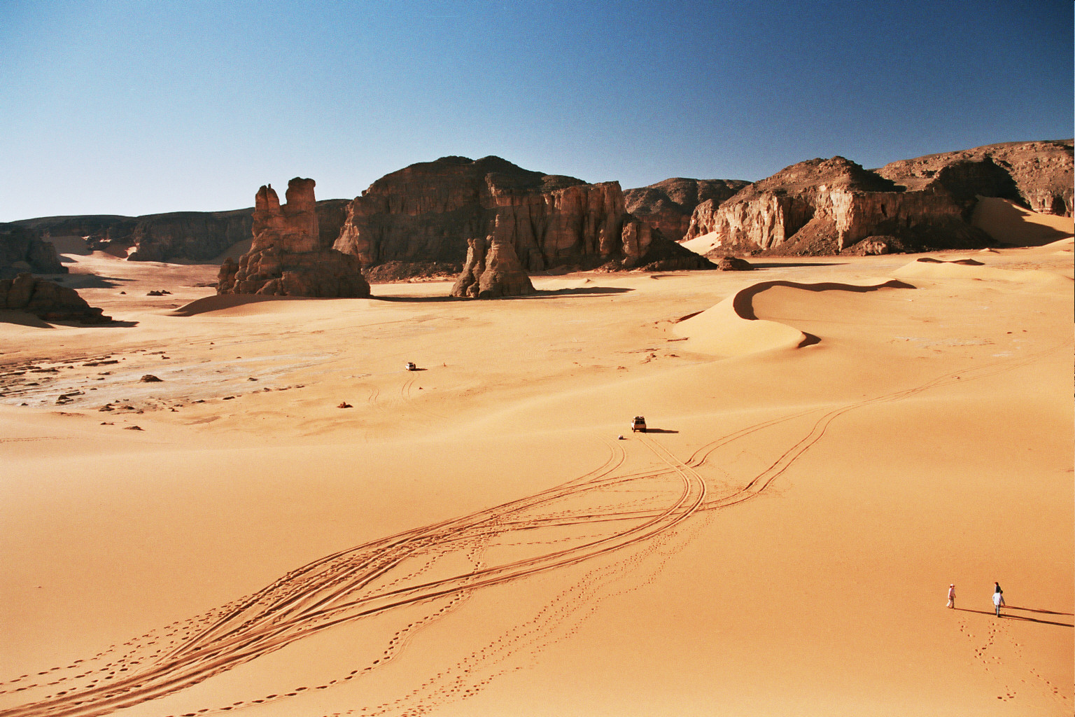
Sandstone towers and arches create maze-like passages across sections of the high plateau.

Check opening days or local access first, then connect the main site to the surrounding streets, paths or landscape instead of treating it as an isolated stop.

Look a little closer

Worth discovering

The details that make Tassili n'Ajjer different.

Destination view
01

Rock forests

Sandstone towers and arches create maze-like passages across sections of the high plateau.

Destination view
02

Prehistoric galleries

Paintings and engravings document changing climates, animals and human societies over thousands of years.

Destination view
03

Tuareg routes

Local knowledge connects water, camps and cultural sites across terrain that appears trackless to outsiders.

Photo journal

A closer look at Tassili n'Ajjer

12 photographs
Origins and change

How Tassili n'Ajjer became the place it is

Sandstone plateaus, rock forests and thousands of prehistoric images preserve both geological and human histories deep in the Sahara. This account follows the forces, communities and decisions that made the present landscape.

Tassili n'Ajjer is a vast plateau in southeastern Algeria near the borders with Libya and Niger. Erosion has shaped sandstone into arches, towers and narrow passages that can resemble ruined cities. Reaching many areas requires long desert approaches and travel with experienced local guides.

The familiar invitation at Tassili n'Ajjer is “Rock forests”, yet that image makes more sense when it is connected to the landform, the local economy and the changes that determined access. Sandstone towers and arches create maze-like passages across sections of the high plateau.

Continue to practical planning
Grand dieu du Sefar 02See the complete photo journal
Physical setting

The landform before the landmark

At Tassili n'Ajjer, the form of the landscape explains many of the choices that came later. Wind, temperature change and ancient water action carved the plateau into a dense rock labyrinth. Sand collects between formations, while higher areas contain relict vegetation that recalls wetter climatic phases. The landscape shifts between open desert, enclosed corridors and elevated views.

Relief controls far more than the view. At Tassili n'Ajjer, “Rock forests” reveals how elevation divides vegetation, weather, water and the routes available to people. Sandstone towers and arches create maze-like passages across sections of the high plateau.

Settlement and memory

Routes, livelihoods and belonging

At Tassili n'Ajjer, people learned to work with the landscape limits rather than arriving after its story was complete. Thousands of paintings and engravings record animals, people and daily activities across several prehistoric periods. They show that the Sahara was not always the hyper-arid environment seen today. Tuareg knowledge, routes and place names remain essential to understanding and moving through the region.

The role of “Prehistoric galleries” is especially revealing at Tassili n'Ajjer. Paintings and engravings document changing climates, animals and human societies over thousands of years. In the history of Tassili n'Ajjer, it connects the wider regional context with a specific place that can still be examined today.

Turning point

The modern turning point

Formal protection changed how Tassili n'Ajjer was described and managed. At Tassili n'Ajjer, new boundaries, visitor rules and conservation priorities created a public identity that still has to coexist with settlements, customary use and economic pressures. At Tassili n'Ajjer, the consequences are clearest where traditional use, protection and tourism occupy the same ground.

Details to read

Three details that explain the whole place

At Tassili n'Ajjer, the feature “Rock forests” is best understood as part of the surrounding system rather than an isolated stop. Sandstone towers and arches create maze-like passages across sections of the high plateau. For Tassili n'Ajjer, that relationship is more informative than treating the feature only as a photograph or checklist item.

Start with the feature “Prehistoric galleries”, because it condenses a much larger part of the story of Tassili n'Ajjer. Paintings and engravings document changing climates, animals and human societies over thousands of years. Within Tassili n'Ajjer, the feature explains why this destination differs from nearby landscapes.

At Tassili n'Ajjer, the feature “Tuareg routes” is best understood as part of the surrounding system rather than an isolated stop. Local knowledge connects water, camps and cultural sites across terrain that appears trackless to outsiders. Its position and condition at Tassili n'Ajjer connect physical history with the way people use the place now.

Living landscape

The current chapter

At Tassili n'Ajjer, light, water and temperature reveal different structures at different times of year. Winter offers cooler days and cold nights, while summer heat is extreme. Sandstorms and large daily temperature ranges can occur in any season. Access also depends on permits, security conditions and logistics that should be assessed through current local authorities.

For Tassili n'Ajjer, the main seasonal constraint is: the strongest planning window is Oct-Mar. For Tassili n'Ajjer, outside it, check weather, daylight, road or ferry schedules and seasonal closures before committing to a fixed route.

For Tassili n'Ajjer, one practical detail matters: distances, fuel, food and mobile coverage can be less predictable than the map suggests. For Tassili n'Ajjer, carry offline maps and keep a margin in the schedule.

Placed within its wider geography, Tassili n'Ajjer is not an isolated exception. For Tassili n'Ajjer, the wider context shows that, the plateau is both an archaeological archive and a living cultural landscape. For Tassili n'Ajjer, rock art is vulnerable to touching, vandalism and unregulated visitation. For Tassili n'Ajjer, its scale demands careful tourism that protects sites while recognizing the expertise of local communities.
Travel notes

Plan your visit

Time needed
3-5 days
Getting around
4x4 or local driver, with short walks at the main sites
Effort
Moderate to demanding
Plan first
Main transport and accommodation
Time of day
Sunrise and the final hours of light
Best window
Oct-Mar
Traveller stories

Stories from people who have been here.

First-hand moments, practical notes and overlooked details from Tassili n'Ajjer.

Loading traveller stories…

Browse all traveller stories ↗

Keep exploring

Where next?

All place stories