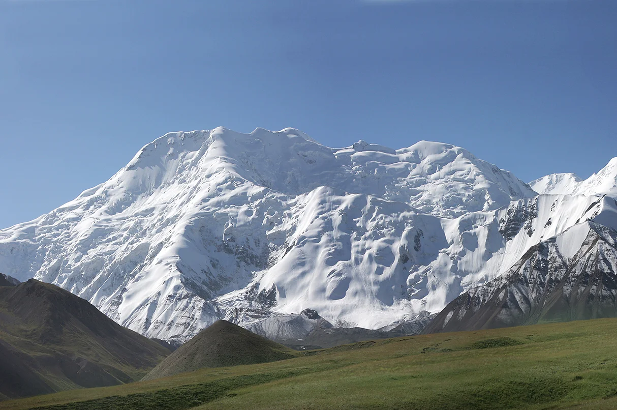
Bumthang high valley

Ura Valley

A broad high valley of clustered houses, fields, monasteries and forested slopes in Bhutan's central Bumthang region.

Clustered villageHigh fieldsMonastic landscape

Location
Bumthang, Bhutan
Best window
Mar-May, Sep-Nov
Suggested stay
2-4 days
Go for
Quiet Himalayan valley
The reason to go

Ura village

Clustered houses and narrow lanes create a strong communal form within the open valley.

Check opening days or local access first, then connect the main site to the surrounding streets, paths or landscape instead of treating it as an isolated stop.

Look a little closer

Worth discovering

The details that make Ura Valley different.

Destination view
01

Ura village

Clustered houses and narrow lanes create a strong communal form within the open valley.

Destination view
02

High agricultural basin

Fields extend around the settlement and reveal adaptation to altitude and a short growing season.

Destination view
03

Monastic landscape

Temples and festivals connect local religious life with the wider cultural geography of Bumthang.

Photo journal

A closer look at Ura Valley

2 photographs
The full story

The landscape memory of Ura Valley

A broad high valley of clustered houses, fields, monasteries and forested slopes in Bhutan's central Bumthang region. This account follows the forces, communities and decisions that made the present landscape.

Ura Valley is best approached through the relationship between its setting and its lived landscape. Ura is one of Bumthang's principal valleys, reached across a high pass and opening into a broad agricultural basin. The main village is unusually compact by Bhutanese standards, with houses grouped along stone lanes beneath surrounding fields and forest. Mountain scale remains present, but the valley's identity is shaped equally by settlement and cultivation.

The strongest visual shorthand for Ura Valley is the experience described as “Ura village”. Behind it lies a more complex relationship between physical processes, settlement and the modern idea of the place as a destination. Clustered houses and narrow lanes create a strong communal form within the open valley.

Continue to practical planning
Ura Mang gi LhakhangSee the complete photo journal
Physical setting

From underlying structure to visible landscape

At Ura Valley, the form of the landscape explains many of the choices that came later. Open fields occupy the gentler floor and lower slopes, while conifer forest climbs toward the ridges. Seasonal streams and high-elevation weather influence agriculture. The approach over the pass reveals the valley gradually, creating a strong contrast between enclosed forest and the open inhabited basin.

The most revealing evidence at Ura Valley is not always monumental. “Ura village” connects everyday use with the larger historical landscape. Clustered houses and narrow lanes create a strong communal form within the open valley.

Settlement and memory

Routes, livelihoods and belonging

Ura Valley has been shaped as much by livelihoods and movement as by natural processes. Traditional houses, a central monastery, local festivals and the cultivation of buckwheat, barley and potatoes contribute to the valley's cultural character. Modern roads and services have changed daily life, yet the clustered settlement pattern and relationship between households and fields remain clearly legible.

At Ura Valley, “High agricultural basin” should not be treated as a decorative detail. Fields extend around the settlement and reveal adaptation to altitude and a short growing season. The feature records how construction, movement or livelihood adapted to local conditions at Ura Valley.

Turning point

How access and attention changed the place

The decisive modern change at Ura Valley was access. At Ura Valley, transport and visitor infrastructure made the landscape easier to reach while concentrating pressure at the few points where roads, boats or trails enter it. At Ura Valley, the consequences are clearest where traditional use, protection and tourism occupy the same ground.

Visible evidence

Landmarks that carry the deeper story

At Ura Valley, the feature “Ura village” provides a precise clue to how the landscape works. Clustered houses and narrow lanes create a strong communal form within the open valley. Within Ura Valley, it is both an attraction and a record of the processes described above.

At Ura Valley, the significance of the feature “High agricultural basin” goes beyond its visual impact. Fields extend around the settlement and reveal adaptation to altitude and a short growing season. Within Ura Valley, it is both an attraction and a record of the processes described above.

At Ura Valley, the feature “Monastic landscape” is one of the most useful pieces of visible evidence. Temples and festivals connect local religious life with the wider cultural geography of Bumthang. Within Ura Valley, it is both an attraction and a record of the processes described above.

Present day

Season, scale and the present day

Ura Valley changes through the year because weather and biological cycles rearrange what can be seen and used. Spring brings flowering trees and fresh fields; autumn often offers clear air and harvest colour. Summer monsoon clouds can obscure the high ridges, while winter is cold and can bring snow. The valley's altitude produces strong daily temperature changes even in the more popular seasons.

For Ura Valley, the main seasonal constraint is: the strongest planning window is Mar-May, Sep-Nov. For Ura Valley, outside it, check weather, daylight, road or ferry schedules and seasonal closures before committing to a fixed route.

For Ura Valley, one practical detail matters: cloud, wind and trail conditions can change quickly. For Ura Valley, put the highest or most exposed stop first and keep a lower-level alternative.

Placed within its wider geography, Ura Valley is not an isolated exception. For Ura Valley, the wider context shows that, ura belongs to the wider Bumthang cultural region with Chokhor, Tang and Chhume valleys. For Ura Valley, temples, pilgrimage routes and mountain passes connect these inhabited basins, each with a different settlement pattern and agricultural character.

Travel notes

Plan your visit

Time needed
2-4 days
Getting around
Car to access points, then walking or hiking
Effort
Moderate
Plan first
Opening days and any limited-entry sites
Time of day
Start early for clearer conditions and more time
Best window
Mar-May, Sep-Nov
Traveller stories

Stories from people who have been here.

First-hand moments, practical notes and overlooked details from Ura Valley.

Loading traveller stories…

Browse all traveller stories ↗

Keep exploring

Where next?

All place stories