Western highlands

Haa Valley

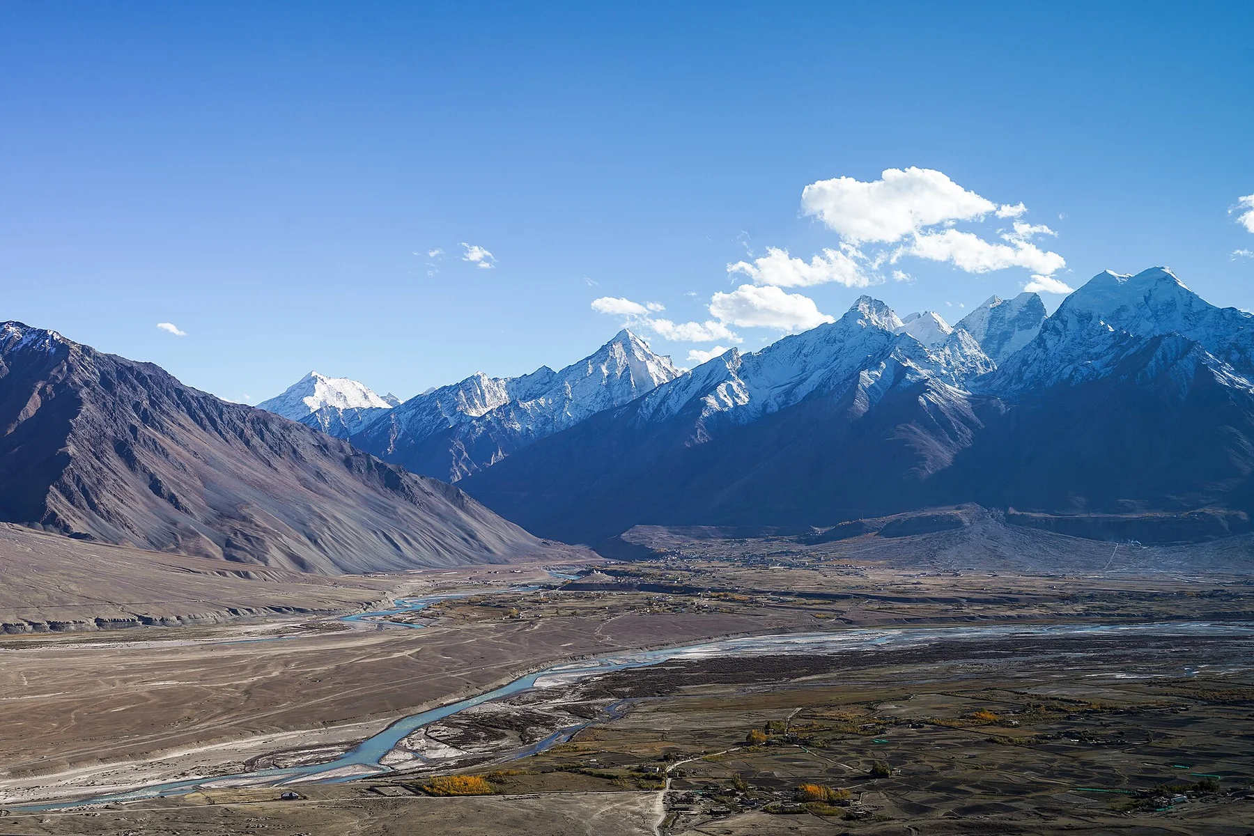
A high western Bhutanese valley of farmhouses, monasteries, pasture and forest beneath ridges leading toward the Himalayan borderlands.

Himalayan valleyFarm villagesMonasteries

Location
Western Bhutan, Bhutan
Best window
Mar-Nov
Suggested stay
2-4 days
Go for
High-valley quiet
The reason to go

Haa town and farms

A modest urban centre opens directly into cultivated fields and traditional houses across the valley floor.

Start early and make this the first exposed stop of the day. Keep a lower route ready if cloud, heat, wind or trail conditions change during Mar-Nov.

Look a little closer

Worth discovering

The details that make Haa Valley different.

Destination view
01

Haa town and farms

A modest urban centre opens directly into cultivated fields and traditional houses across the valley floor.

Destination view
02

White and Black temples

Two important religious sites anchor local history within the wider settlement landscape.

Destination view
03

Chele La approach

The high pass route reveals the valley's scale and its relationship with the mountains of western Bhutan.

Photo journal

A closer look at Haa Valley

13 photographs
Beyond the surface

The landscape memory of Haa Valley

A high western Bhutanese valley of farmhouses, monasteries, pasture and forest beneath ridges leading toward the Himalayan borderlands. The deeper story links its visible features with the people and changes behind them.

Haa Valley lies west of Paro in a broad, high basin surrounded by forested mountains. Farmhouses, fields and small settlements occupy the gentler valley floor, while religious sites and pasture extend onto the lower slopes. Its relative distance from Bhutan's busiest visitor routes gives the landscape a measured, inhabited calm.

The strongest visual shorthand for Haa Valley is the experience described as “Haa town and farms”. Behind it lies a more complex relationship between physical processes, settlement and the modern idea of the place as a destination. A modest urban centre opens directly into cultivated fields and traditional houses across the valley floor.

Continue to practical planning
Chelela to Paro road views during LGFC - Bhutan 2019 (111)See the complete photo journal
Landform

The physical foundations of the place

Understanding Haa Valley starts below the visible surface. The Haa Chhu river and its tributaries organise the valley, separating cultivated land from forest and higher grazing areas. Conifer-covered ridges enclose the basin without making it feel narrow. From Chele La and other high approaches, the valley appears as a patchwork of fields beneath a much larger Himalayan skyline.

Built remains and terrain should be at Haa Valley, considered together. At Haa Valley, “Haa town and farms” shows how the setting influenced location, materials and later survival. A modest urban centre opens directly into cultivated fields and traditional houses across the valley floor.

Cultural landscape

Routes, livelihoods and belonging

At Haa Valley, people learned to work with the landscape limits rather than arriving after its story was complete. Traditional houses, local schools, military facilities and monasteries coexist within the valley. Lhakhang Karpo and Lhakhang Nagpo are central religious landmarks, while seasonal farming and livestock remain visible around smaller villages. The landscape feels contemporary and lived in rather than preserved only for visitors.

The role of “White and Black temples” is especially revealing at Haa Valley. Two important religious sites anchor local history within the wider settlement landscape. In the history of Haa Valley, it connects the wider regional context with a specific place that can still be examined today.

Modern history

The change that redefined the place

Formal protection changed how Haa Valley was described and managed. At Haa Valley, new boundaries, visitor rules and conservation priorities created a public identity that still has to coexist with settlements, customary use and economic pressures. At Haa Valley, that transition remains visible in the contrast between older working features and visitor infrastructure.

Field notes

Where the story becomes visible

At Haa Valley, the significance of the feature “Haa town and farms” goes beyond its visual impact. A modest urban centre opens directly into cultivated fields and traditional houses across the valley floor. At Haa Valley, it gives a concrete reference point for reading change rather than merely collecting viewpoints.

At Haa Valley, the feature “White and Black temples” is one of the most useful pieces of visible evidence. Two important religious sites anchor local history within the wider settlement landscape. Within Haa Valley, it is both an attraction and a record of the processes described above.

Look closely at the feature “Chele La approach” in Haa Valley; it carries information that a panoramic view can miss. The high pass route reveals the valley's scale and its relationship with the mountains of western Bhutan. At Haa Valley, it gives a concrete reference point for reading change rather than merely collecting viewpoints.

Living landscape

Season, scale and the present day

At Haa Valley, light, water and temperature reveal different structures at different times of year. Spring brings clear intervals and renewed field activity. Summer is green but affected by monsoon cloud and rain. Autumn generally offers stable views and harvest colour, while winter can be dry, cold and quiet, with snow possible on the passes even when the valley floor remains open.

For Haa Valley, the main seasonal constraint is: the strongest planning window is Mar-Nov. For Haa Valley, outside it, check weather, daylight, road or ferry schedules and seasonal closures before committing to a fixed route.

For Haa Valley, one practical detail matters: cloud, wind and trail conditions can change quickly. For Haa Valley, put the highest or most exposed stop first and keep a lower-level alternative.

Placed within its wider geography, Haa Valley is not an isolated exception. For Haa Valley, the wider context shows that, haa can be linked with Paro across Chele La or approached as part of a slower circuit through western Bhutan. For Haa Valley, the valley adds agricultural and village context to the country's better-known fortress-monasteries and high Himalayan viewpoints.

Travel notes

Plan your visit

Time needed
2-4 days
Getting around
Car to access points, then walking or hiking
Effort
Moderate
Plan first
Opening days and any limited-entry sites
Time of day
Start early for clearer conditions and more time
Best window
Mar-Nov
Traveller stories

Stories from people who have been here.

First-hand moments, practical notes and overlooked details from Haa Valley.

Loading traveller stories…

Browse all traveller stories ↗

Keep exploring

Where next?

All place stories