Happy Valley

Ait Bouguemez

Irrigated fields, earthen villages and high mountain ridges form a broad inhabited valley in Morocco's central High Atlas.

Earthen villagesTerraced fieldsMountain granaries

Location
High Atlas, Morocco
Best window
Apr-Jun, Sep-Oct
Suggested stay
2-4 days
Go for
High Atlas village valley
The reason to go

Valley fields

Irrigation turns the broad floor into a mosaic of crops and orchards beneath dry mountains.

Start early and make this the first exposed stop of the day. Keep a lower route ready if cloud, heat, wind or trail conditions change during Apr-Jun, Sep-Oct.

Look a little closer

Worth discovering

The details that make Ait Bouguemez different.

Destination view
01

Valley fields

Irrigation turns the broad floor into a mosaic of crops and orchards beneath dry mountains.

Destination view
02

Earthen villages

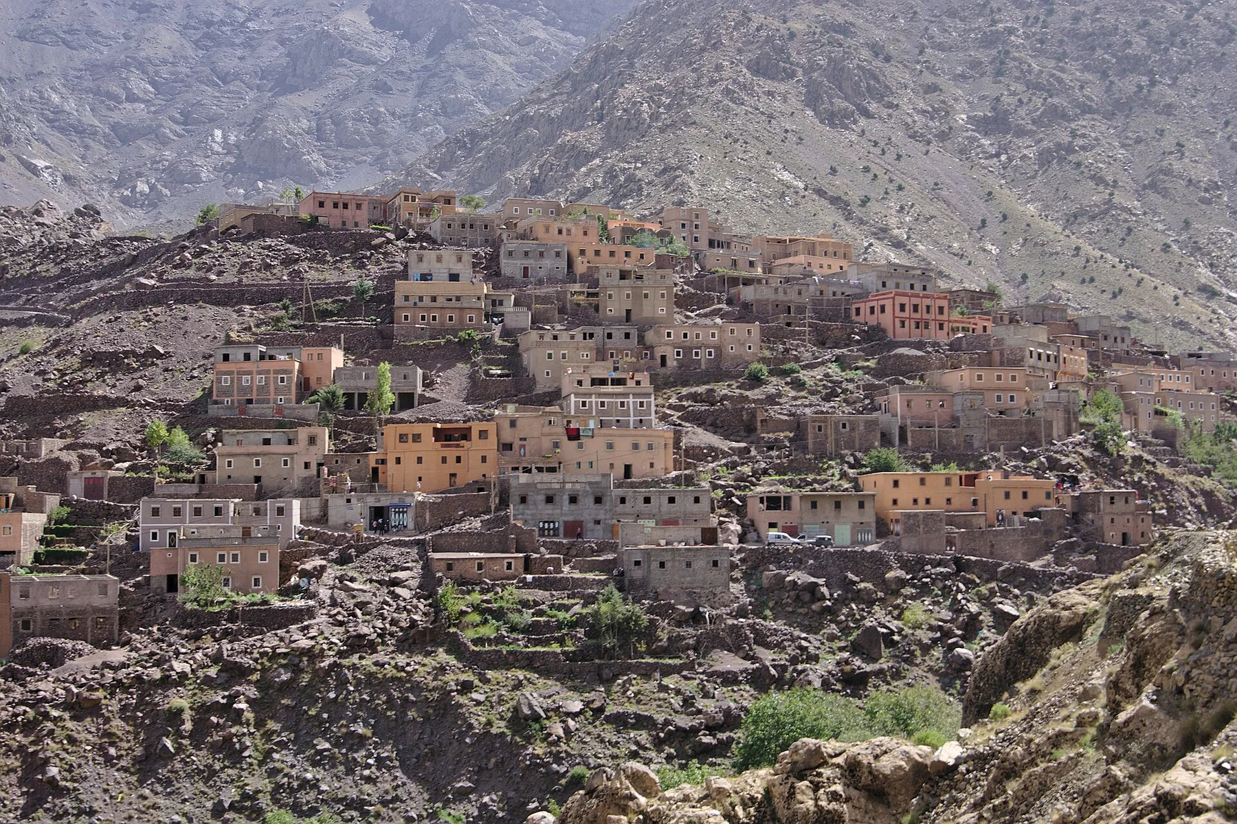
Compact settlements rise from the slopes in colours closely matched to local soil and stone.

Destination view
03

Communal granaries

Historic fortified storage structures reveal collective approaches to security and resources.

Photo journal

A closer look at Ait Bouguemez

9 photographs
Beyond the surface

Ait Bouguemez: the story behind the landscape

Irrigated fields, earthen villages and high mountain ridges form a broad inhabited valley in Morocco's central High Atlas. Its character becomes clearer when geology, settlement and modern protection are considered together.

Ait Bouguemez is a broad, cultivated valley enclosed by high Atlas ridges. Fields, orchards and irrigation channels occupy the floor, while earthen villages rise slightly above the most productive land. The openness of the valley distinguishes it from narrower mountain gorges and makes the relationship between water, agriculture and settlement especially clear.

Many visits to Ait Bouguemez begin with the experience described as “Valley fields”. The more revealing question is why it exists here, how people used the surrounding ground and what remains visible from earlier phases. Irrigation turns the broad floor into a mosaic of crops and orchards beneath dry mountains.

Continue to practical planning
Ait Bouguemez — view 4See the complete photo journal
Landform

How the landscape was assembled

At Ait Bouguemez, the form of the landscape explains many of the choices that came later. Snowmelt and springs feed channels that distribute water through barley fields, orchards and gardens. Above the green valley floor, dry slopes rise toward high plateaus and peaks. Seasonal contrast is strong: productive land forms a vivid ribbon within a much more austere mountain environment.

The skyline is only the upper edge of a larger system. At Ait Bouguemez, “Valley fields” connects the high ground with valleys, settlement and the movement of water below. Irrigation turns the broad floor into a mosaic of crops and orchards beneath dry mountains.

Lives and livelihoods

People, work and memory

At Ait Bouguemez, human history is written into settlement and land use rather than separated from the scenery. Amazigh villages, communal resource systems and fortified granaries reflect long adaptation to altitude and limited water. Architecture uses earth and stone in forms closely matched to the landscape. Roads and new construction are changing settlement patterns, but the valley remains visibly organised around agriculture.

A close look at “Earthen villages” makes the cultural layer of Ait Bouguemez more concrete. Compact settlements rise from the slopes in colours closely matched to local soil and stone. At Ait Bouguemez, the surviving form links present-day identity with earlier work and settlement.

Turning point

What altered the old balance

The decisive modern change at Ait Bouguemez was access. At Ait Bouguemez, transport and visitor infrastructure made the landscape easier to reach while concentrating pressure at the few points where roads, boats or trails enter it. At Ait Bouguemez, the consequences are clearest where traditional use, protection and tourism occupy the same ground.

On the ground

Landmarks that carry the deeper story

Start with the feature “Valley fields”, because it condenses a much larger part of the story of Ait Bouguemez. Irrigation turns the broad floor into a mosaic of crops and orchards beneath dry mountains. For Ait Bouguemez, that relationship is more informative than treating the feature only as a photograph or checklist item.

At Ait Bouguemez, the feature “Earthen villages” is one of the most useful pieces of visible evidence. Compact settlements rise from the slopes in colours closely matched to local soil and stone. Within Ait Bouguemez, the feature explains why this destination differs from nearby landscapes.

At Ait Bouguemez, the feature “Communal granaries” is best understood as part of the surrounding system rather than an isolated stop. Historic fortified storage structures reveal collective approaches to security and resources. For Ait Bouguemez, that relationship is more informative than treating the feature only as a photograph or checklist item.

Present day

What continues to change

Ait Bouguemez changes through the year because weather and biological cycles rearrange what can be seen and used. Spring brings flowing water, active fields and snow on higher ridges. Early autumn combines harvest colour with stable mountain conditions. Summer can be hot on exposed ground, while winter cold and snow affect passes and village life.

For Ait Bouguemez, the main seasonal constraint is: the strongest planning window is Apr-Jun, Sep-Oct. For Ait Bouguemez, outside it, check weather, daylight, road or ferry schedules and seasonal closures before committing to a fixed route.

For Ait Bouguemez, one practical detail matters: cloud, wind and trail conditions can change quickly. For Ait Bouguemez, put the highest or most exposed stop first and keep a lower-level alternative.

Placed within its wider geography, Ait Bouguemez is not an isolated exception. For Ait Bouguemez, the wider context shows that, the valley lies near the M'Goun massif and connects with other central High Atlas valleys through passes and long mountain roads. For Ait Bouguemez, the contrast with the desert-facing southern slopes and the greener northern approaches shows the environmental range of the Atlas system.

Travel notes

Plan your visit

Time needed
2-4 days
Getting around
Car to access points, then walking or hiking
Effort
Moderate
Plan first
Opening days and any limited-entry sites
Time of day
Start early for clearer conditions and more time
Best window
Apr-Jun, Sep-Oct
Traveller stories

Stories from people who have been here.

First-hand moments, practical notes and overlooked details from Ait Bouguemez.

Loading traveller stories…

Browse all traveller stories ↗

Keep exploring

Where next?

All place stories
