Mountain life below Toubkal

Toubkal Valleys

High Atlas valleys, Amazigh villages, walnut terraces and snow-fed streams surround North Africa highest mountain.

Amazigh villagesHigh Atlas peaksTerraced valleys

Location
High Atlas, Morocco
Best window
Apr-Jun, Sep-Oct
Suggested stay
2-4 days
Go for
High valley and village trekking
The reason to go

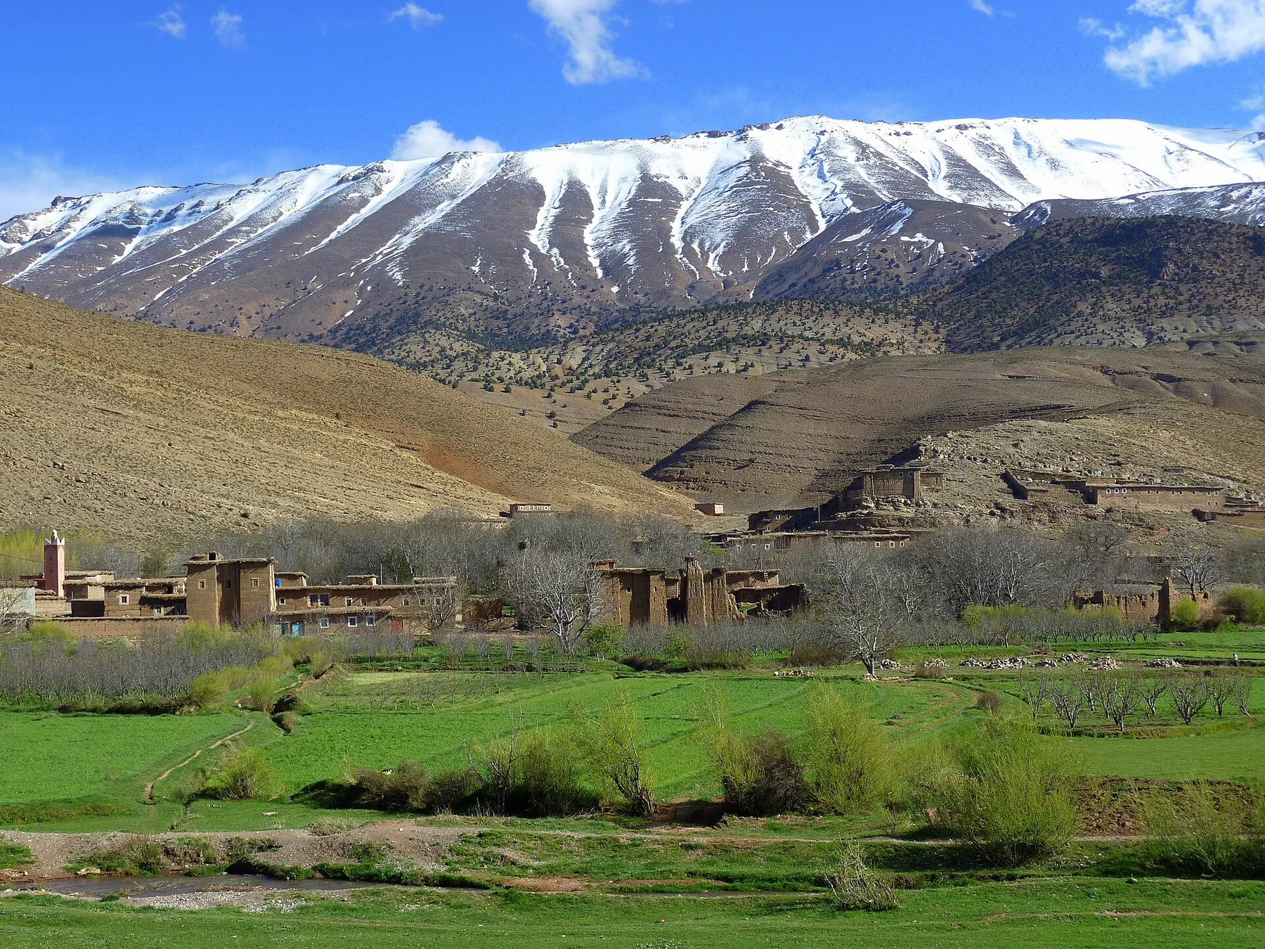
Aroumd and Imlil valley

Terraced villages and the main mountain approach reveal the most accessible relationship between settlement and high peaks.

Start early and make this the first exposed stop of the day. Keep a lower route ready if cloud, heat, wind or trail conditions change during Apr-Jun, Sep-Oct.

Look a little closer

Worth discovering

The details that make Toubkal Valleys different.

Photo journal
01

Aroumd and Imlil valley

Terraced villages and the main mountain approach reveal the most accessible relationship between settlement and high peaks.

Destination view
02

Azzaden valley

Quieter paths, walnut groves and red-earth villages provide a broader view of the massif.

Destination view
03

High passes

Crossings between valleys show the scale of the Atlas and the historic importance of foot routes.

Photo journal

A closer look at Toubkal Valleys

9 photographs
Origins and change

How time shaped Toubkal Valleys

High Atlas valleys, Amazigh villages, walnut terraces and snow-fed streams surround North Africa highest mountain. The view is only the surface of a longer story of formation, use and change.

Toubkal Valleys is best approached through the relationship between its setting and its lived landscape. The Toubkal region is more than the summit route. Several valleys radiate from the high central massif, each containing villages, cultivated terraces, walnut groves and seasonal streams. The contrast between dry lower slopes and snow-fed upper basins gives the landscape strong vertical structure.

Visitors often encounter Toubkal Valleys through the idea of “Aroumd and Imlil valley”, but the destination is more than that single scene. Its landscape carries evidence of work, movement, adaptation and environmental change. Terraced villages and the main mountain approach reveal the most accessible relationship between settlement and high peaks.

Continue to practical planning
Morocco Toubkal National Park Imlil ValleySee the complete photo journal
Landform

From underlying structure to visible landscape

The first layer of Toubkal Valleys is geological and ecological rather than scenic. Rocky ridges and deeply cut valleys dominate, with snow lingering on the highest peaks into summer. Paths connect settlements across passes and along water channels. In lower valleys, irrigation creates ribbons of green against brown mountain walls.

The skyline is only the upper edge of a larger system. At Toubkal Valleys, “Aroumd and Imlil valley” connects the high ground with valleys, settlement and the movement of water below. Terraced villages and the main mountain approach reveal the most accessible relationship between settlement and high peaks.

Human history

Lives shaped by the terrain

At Toubkal Valleys, human history is written into settlement and land use rather than separated from the scenery. Amazigh communities have shaped the valleys through terracing, grazing, architecture and local trail networks. Imlil is the principal trekking hub, but smaller villages reveal a more everyday relationship between tourism, agriculture and seasonal labour.

At Toubkal Valleys, the feature described as “Azzaden valley” offers a second line of evidence. Quieter paths, walnut groves and red-earth villages provide a broader view of the massif. Within Toubkal Valleys, it shows how local knowledge and practical use became embedded in the landscape.

Change

The modern turning point

The decisive modern change at Toubkal Valleys was access. At Toubkal Valleys, transport and visitor infrastructure made the landscape easier to reach while concentrating pressure at the few points where roads, boats or trails enter it. At Toubkal Valleys, the result is not a clean break with the past because earlier routes and habits continue to organise the present landscape.

On the ground

The small features that reveal the larger pattern

At Toubkal Valleys, the significance of the feature “Aroumd and Imlil valley” goes beyond its visual impact. Terraced villages and the main mountain approach reveal the most accessible relationship between settlement and high peaks. For Toubkal Valleys, that relationship is more informative than treating the feature only as a photograph or checklist item.

Look closely at the feature “Azzaden valley” in Toubkal Valleys; it carries information that a panoramic view can miss. Quieter paths, walnut groves and red-earth villages provide a broader view of the massif. At Toubkal Valleys, the detail links local scale with the wider regional pattern.

Look closely at the feature “High passes” in Toubkal Valleys; it carries information that a panoramic view can miss. Crossings between valleys show the scale of the Atlas and the historic importance of foot routes. At Toubkal Valleys, the detail links local scale with the wider regional pattern.

Present day

Season, scale and the present day

Toubkal Valleys changes through the year because weather and biological cycles rearrange what can be seen and used. Spring and early autumn generally offer the best balance for valley walking. Summer can be hot at lower elevations and busy on the summit route, while winter brings snow, cold and the need for mountain equipment. Conditions vary sharply with altitude.

For Toubkal Valleys, the main seasonal constraint is: the strongest planning window is Apr-Jun, Sep-Oct. For Toubkal Valleys, outside it, check weather, daylight, road or ferry schedules and seasonal closures before committing to a fixed route.

For Toubkal Valleys, one practical detail matters: cloud, wind and trail conditions can change quickly. For Toubkal Valleys, put the highest or most exposed stop first and keep a lower-level alternative.

Placed within its wider geography, Toubkal Valleys is not an isolated exception. For Toubkal Valleys, the wider context shows that, the central High Atlas connects west toward Ouirgane and east toward less-visited valleys. For Toubkal Valleys, a multi-valley route shows how settlement and agriculture continue around the entire massif rather than concentrating in one trailhead.

Travel notes

Plan your visit

Time needed
2-4 days
Getting around
Car to access points, then walking or hiking
Effort
Moderate to demanding
Plan first
Opening days and any limited-entry sites
Time of day
Start early for clearer conditions and more time
Best window
Apr-Jun, Sep-Oct
Traveller stories

Stories from people who have been here.

First-hand moments, practical notes and overlooked details from Toubkal Valleys.

Loading traveller stories…

Browse all traveller stories ↗

Keep exploring

Where next?

All place stories
