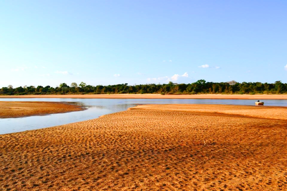
Travel by boat between a sand beach and a flooded forest channel
The park is best understood from the water, where dry-season beach, river current and wetland forest appear in quick succession.
Use an experienced local guide and begin early, when wildlife activity, water levels and cooler conditions are most favourable.
Look a little closer
Worth discovering
The details that make Araguaia National Park different.
Destination view
01
Araguaia River beaches
Broad sandbars form seasonal camps and wildlife sites.
Destination view
02
Wetland lagoons
Shallow water supports birds and aquatic life.
Photo journal
03
Gallery forest
Dense tree corridors follow channels across open floodplain.
Photo journal
A closer look at Araguaia National Park
4 photographs
01Garça no Rio Araguaia02Araguaia03Vista do Parque Nacional do Araguaia 304Vista do Parque Nacional do Araguaia 2
Beyond the surface
The landscape memory of Araguaia National Park
River beaches, wetlands and gallery forest protect the northern end of Bananal Island. The view is only the surface of a longer story of formation, use and change.
4 min readNorthern Bananal Island, Brazil
Araguaia National Park is centred on Northern Bananal Island, where river beaches, wetlands and gallery forest protect the northern end of Bananal Island. The strongest reason to make the journey is to travel by boat between a sand beach and a flooded forest channel.
The strongest visual shorthand for Araguaia National Park is the experience described as “Travel by boat between a sand beach and a flooded forest channel”. Behind it lies a more complex relationship between physical processes, settlement and the modern idea of the place as a destination. The park is best understood from the water, where dry-season beach, river current and wetland forest appear in quick succession.
The first layer of Araguaia National Park is geological and ecological rather than scenic. Water level determines the route, wildlife concentration and what ground is accessible. Boat or canoe travel often reveals more than a road-based visit.
Water continually redraws the practical map of Araguaia National Park. “Araguaia River beaches” is one of the clearest places to see channels, vegetation and open ground exchange roles. Broad sandbars form seasonal camps and wildlife sites.
02
Lives and livelihoods
The human landscape behind the scenery
Araguaia National Park was created in 1959 during a period when Brazil sought monumental inland protected areas. The original boundaries covered much of Bananal Island, despite the presence and rights of Karaja and Javae communities.
Subsequent boundary changes moved and reduced the park as Indigenous lands and settlement claims were recognised. The remaining northern section protects floodplain forest, grassland and channels within a far more complex governance mosaic.
03
Modern history
The modern turning point
The park's history is a lesson in conservation imposed from above and later corrected imperfectly. Effective protection now depends on coordination with Indigenous territories that retain much of the island's ecological continuity.
04
Visible evidence
What to read in the landscape
Start with the feature “Araguaia River beaches”, because it condenses a much larger part of the story of Araguaia National Park. Broad sandbars form seasonal camps and wildlife sites. Within Araguaia National Park, it is both an attraction and a record of the processes described above.
At Araguaia National Park, the significance of the feature “Wetland lagoons” goes beyond its visual impact. Shallow water supports birds and aquatic life. Within Araguaia National Park, the feature explains why this destination differs from nearby landscapes.
Look closely at the feature “Gallery forest” in Araguaia National Park; it carries information that a panoramic view can miss. Dense tree corridors follow channels across open floodplain. Within Araguaia National Park, it is both an attraction and a record of the processes described above.
05
Continuity
The current chapter
At Araguaia National Park, season is part of the landscape history, not merely a planning detail. For Araguaia National Park, the most reliable visiting window is May-Sep.
For Araguaia National Park, the stated visiting window is May-Sep, but its practical meaning depends on local weather, water and transport rather than the calendar alone.
Placed within its wider geography, Araguaia National Park is not an isolated exception. Beyond the best-known image of Araguaia National Park feature, Araguaia National Park matters because wetland lagoons and gallery forest place the destination inside a broader regional story.
Chronology
Key dates
Large national park declared
Federal planners designated a vast area of Bananal Island for conservation.
Boundary conflict and reduction
Indigenous rights, ranching and administration forced repeated redefinition.
A park within an Indigenous mosaic
Floodplain conservation depends on cooperation across several legal territories.
Travel notes
Plan your visit
Time needed
2-4 days
Getting around
Boat or canoe, plus short walks from landing points
Effort
Easy to moderate
Plan first
Water level, boat and local guide
Time of day
Early morning and late afternoon
Best window
May-Sep
Traveller stories
Stories from people who have been here.
First-hand moments, practical notes and overlooked details from Araguaia National Park.