A soft-edged Balkan range

Osogovo

A broad border mountain of beech forest, high pasture, monasteries and mining traces, quieter than the sharper Balkan ranges around it.

MountainsBorderlandsMonasteries

Location
Central Balkans, North Macedonia and Bulgaria
Best window
May-Oct
Suggested stay
2-4 days
Go for
Unhurried highland walking
The reason to go

A mountain for long horizons and local detail

Osogovo's rounded summits and forest roads favour steady exploration, while monasteries, shepherd landscapes and old extraction sites add cultural depth to the high country.

Stay long enough to connect Osogovo's headline landscape with one quieter local route rather than treating it as a single viewpoint.
Look a little closer

Worth discovering

The details that make Osogovo different.

Destination view
01

A shared massif

The mountain crosses a modern national border but remains one continuous ecological and pastoral landscape.

Destination view
02

Volcanic and mineral history

Ancient geological processes and mining have left distinctive rocks, workings and settlement patterns.

Destination view
03

Monasteries below the summits

Religious complexes occupy wooded slopes and connect mountain routes with regional history and art.

Photo journal

A closer look at Osogovo

4 photographs
Deep background

The making of Osogovo

A broad border mountain of beech forest, high pasture, monasteries and mining traces, quieter than the sharper Balkan ranges around it. The view is only the surface of a longer story of formation, use and change.

Osogovo's rounded summits and forest roads favour steady exploration, while monasteries, shepherd landscapes and old extraction sites add cultural depth to the high country.

The familiar invitation at Osogovo is “Unhurried highland walking”, yet that image makes more sense when it is connected to the landform, the local economy and the changes that determined access. At Osogovo, allow enough time to connect Osogovo's headline landscape with one quieter local route instead of reducing Osogovo to a single viewpoint.

Continue to practical planning
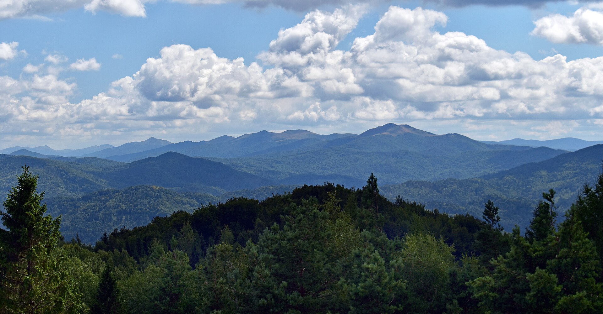
Blick vom Strumatal nach Westen zum Osogovo 3See the complete photo journal
Physical setting

How the landscape was assembled

Before roads, settlements or protected-area boundaries, the terrain of Osogovo set the basic terms. Rounded peaks, volcanic geology, beech and oak forest, streams and summer pasture create a gentler profile than nearby limestone massifs.

Relief controls far more than the view. At Osogovo, “A shared massif” reveals how elevation divides vegetation, weather, water and the routes available to people. The mountain crosses a modern national border but remains one continuous ecological and pastoral landscape.

Settlement and memory

The human landscape behind the scenery

Osogovo's forests and high pastures lie across a long Balkan frontier used by shepherds, miners, merchants and monastic communities. Medieval mining exploited lead, zinc and other ores, while monasteries such as Saint Joachim of Osogovo became religious and economic anchors on the mountain's approaches.

Ottoman rule redirected trade and taxation but did not end mining or seasonal pastoral movement. The modern boundary between Bulgaria and North Macedonia hardened after the Balkan Wars, dividing a mountain system whose villages and routes had previously faced several political centres.

Change

From local landscape to protected destination

Recent transboundary conservation initiatives attempt to manage habitats across that border, while mines, forestry and depopulation continue to shape the region. Monastery complexes, old workings, ridge pastures and border markers make Osogovo's layered use visible.

Details to read

Where the story becomes visible

At Osogovo, the feature “A shared massif” is one of the most useful pieces of visible evidence. The mountain crosses a modern national border but remains one continuous ecological and pastoral landscape. Its position and condition at Osogovo connect physical history with the way people use the place now.

At Osogovo, the feature “Volcanic and mineral history” is best understood as part of the surrounding system rather than an isolated stop. Ancient geological processes and mining have left distinctive rocks, workings and settlement patterns. Within Osogovo, it is both an attraction and a record of the processes described above.

Look closely at the feature “Monasteries below the summits” in Osogovo; it carries information that a panoramic view can miss. Religious complexes occupy wooded slopes and connect mountain routes with regional history and art. At Osogovo, it gives a concrete reference point for reading change rather than merely collecting viewpoints.

Continuity

Season, scale and the present day

Osogovo changes through the year because weather and biological cycles rearrange what can be seen and used. May and June are green and flower-rich, midsummer can be hot in lower valleys, and September offers clear walking weather. Snow lingers on exposed winter routes.

For Osogovo, the most useful time of day is: late light on the open ridges.

For Osogovo, plan this first: trailhead access and border-side route.

Placed within its wider geography, Osogovo is not an isolated exception. For Osogovo, the wider context shows that, kratovo, Kriva Palanka and Kyustendil add historic towns, stone architecture and thermal landscapes to a mountain itinerary.

Chronology

Key dates

  1. Mining and monasteries

    Ore extraction and religious estates connected the mountain to regional towns and rulers.

  2. Pastoral and commercial continuity

    Villages maintained seasonal land use within a new imperial system.

  3. International border divides the range

    New national frontiers separated communities and administration across one mountain landscape.

In context

Get to know the place

The landscape

Rounded peaks, volcanic geology, beech and oak forest, streams and summer pasture create a gentler profile than nearby limestone massifs.

People and place

Villages on both sides of the range combine farming, forestry, mining memory and religious traditions, with mountain use changing as populations decline.

Seasonal character

May and June are green and flower-rich, midsummer can be hot in lower valleys, and September offers clear walking weather. Snow lingers on exposed winter routes.

Beyond the main view

Kratovo, Kriva Palanka and Kyustendil add historic towns, stone architecture and thermal landscapes to a mountain itinerary.

Travel notes

Plan your visit

Time needed
2-4 days
Getting around
Car and hiking
Effort
Moderate
Plan first
Trailhead access and border-side route
Time of day
Late light on the open ridges
Best window
May-Oct
Keep exploring

Where next?

All place stories